
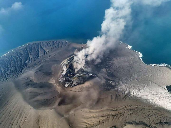
Anak Krakatau Returned to Level III as Eruptive Activity Increased
Kabarsaji.com – Authorities have raised the alert status for Mount Anak Krakatau in the Sunda Strait to Level III, known as Watch, after monitoring showed a renewed increase in volcanic activity. The designation took effect at 21:00 Western Indonesian Time on Friday, October 9, 2026.
The move comes less than three weeks after the volcano’s status had been reduced to Level II, or Caution, on September 21. The renewed escalation reflects a series of seismic events and eruptions observed in the period from September 21 through October 8.
Monitoring data recorded five eruption earthquakes and eight explosion earthquakes during that interval. Officials also noted 11 low-frequency earthquakes, 45 many-phase earthquakes, 17 episodes of continuous tremor, 31 shallow volcanic earthquakes, and nine deep volcanic earthquakes. These measurements are used to assess changes beneath and around an active volcano, including movement of volcanic materials and pressure within its system.
Nine Eruptions Recorded on October 9
Activity remained elevated on Friday, when nine eruptions were documented by 19:20 WIB. The largest recorded amplitude reached 55 millimeters, while the longest eruption lasted 32 seconds. The height of the eruption column could not be observed.
“Throughout Friday, October 9, 2026, until 19:20, there were nine eruptions with a maximum amplitude of 55 millimeters and an eruption duration of 32 seconds with the height of the eruption column unobserved,” said the Head of the Geological Agency, Lana Saria, in a written statement.
Anak Krakatau is the active volcanic island that emerged in the Sunda Strait following the historic Krakatau eruption of 1883. Its activity is closely watched because the volcano lies between Java and Sumatra, near coastal communities in Banten and Lampung provinces. Changes in the alert level are intended to guide public safety measures and restrictions around the volcano rather than to signal that everyday activity must stop across the wider region.
Five-Kilometer Restricted Area Reinstated
With the volcano again placed at Level III, the public and visitors are prohibited from approaching within five kilometers of Anak Krakatau’s main eruption crater. Access is also barred within one kilometer of the newer land area, particularly in the northwestern and southeastern sectors.
The restrictions are designed to reduce exposure to hazards that can develop quickly during eruptions. The Geological Agency warned of possible lava bombs, heavy ashfall, lava flows, and secondary eruptions. Secondary eruptions can occur when hot lava comes into contact with seawater or rainwater, potentially producing sudden explosive activity around the eruption center.
People who travel by sea or work near the restricted waters should remain attentive to official guidance. Visitors should not treat clearer weather, a temporary lull in visible eruptions, or online speculation as a reason to enter the exclusion zone. Conditions at active volcanoes can change rapidly, and visibility alone does not provide a complete picture of activity beneath the surface.
Coastal Residents Urged to Remain Calm
Residents along the Banten and Lampung coasts have been encouraged to stay calm and continue their normal routines while following directions from local disaster management authorities. Officials also cautioned against circulating or relying on unverified claims that an Anak Krakatau eruption will automatically cause a tsunami.
“The community in the coastal areas of Banten and Lampung provinces is urged to remain calm and not to trust rumors about an eruption of Mount Anak Krakatau that could lead to a tsunami, and they can carry out normal activities while always following the guidance of local disaster management agencies,” Lana said in a further statement.
For communities near the Sunda Strait, the practical message is to rely on official alerts, local disaster authorities, and clearly communicated evacuation instructions if they are issued. Rumors can create unnecessary anxiety, while verified warnings provide the information needed for people to make safe decisions.
The Level III designation had previously been in place from July 2 until September 21. During that earlier period, Anak Krakatau produced continuous eruptions from September 4 to September 6. Volcanic ash from those events spread toward Greater Jakarta and West Sumatra.
Earlier activity also altered the physical landscape of Anak Krakatau. In addition to enlarging the island’s land area, the eruptions formed two new areas of land. Such changes underscore the shifting nature of the volcano, where eruptive materials can reshape the island and surrounding shoreline over time.
The latest increase in status means monitoring will remain especially important in the days ahead. The Level III warning focuses on limiting activity near the volcano, maintaining awareness of ash and projectile hazards, and ensuring coastal communities receive reliable information through official disaster-management channels.
Related Reading
Frequently Asked Questions
What is Mount Anak Krakatau Eruptions Intensify Alert?
Mount Anak Krakatau Eruptions Intensify Alert is the main topic of this guide. The article explains the context, practical details, and next steps readers should understand.
Why does Mount Anak Krakatau Eruptions Intensify Alert matter?
Mount Anak Krakatau Eruptions Intensify Alert matters because readers are looking for a useful answer, not just a short summary. Good content should match search intent and help them decide what to do next.