
Oil Spills Raise Alarm Across the Strait of Hormuz
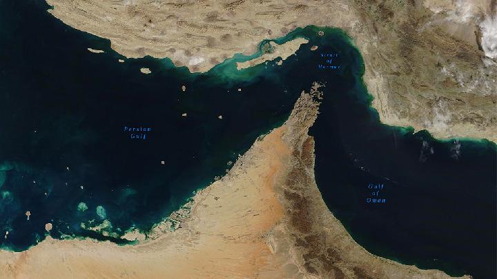
Kabarsaji.com – Satellite images are revealing signs of oil contamination in the Strait of Hormuz as the US-Iran war places tankers and coastal ecosystems under increasing pressure. Darkened water, pale winding trails and a metallic-looking surface sheen have all appeared in imagery reviewed by environmental experts, suggesting that oil is entering the Persian Gulf after vessels were hit, burned or sunk.
The Strait of Hormuz is one of the world’s most sensitive maritime passages. Its narrow waters connect the Persian Gulf with the Gulf of Oman, and the concentration of oil tankers moving through the area means that any military escalation can quickly become an environmental emergency.
In June, a Russian tanker carrying roughly 800,000 barrels of oil became stranded off Oman’s coast, resulting in a significant spill. During an earlier phase of the conflict, Greenpeace counted as many as 85 large tankers carrying oil that were unable to leave the strait. That number has since fallen to 13, but vessels remaining in the area continue to face the danger of attack and possible fuel releases.
Since the war began, Greenpeace has tracked more than 100 spills through satellite monitoring. The true total may be higher because GPS spoofing has become widespread in the region, causing ships to transmit inaccurate locations and making it harder to establish where incidents occurred.
Protected coastal areas in the path of slicks
Greenpeace recently mapped five major slicks with a combined visible area of 240 square kilometers, or about 90 square miles. At their largest observed extent, the contaminated surface area was roughly four times Manhattan’s size.
Newer images indicate that the slicks have broken up and now cover about 80 square kilometers at the surface. Weather and ocean conditions may have dispersed the oil, but a smaller visible footprint does not necessarily mean that the threat has passed. Oil can move below the surface, settle into seabed sediment or reach shorelines beyond the areas immediately apparent in satellite images.
“Oil can also sink into the sediment and impact the ecosystems for years and years.”
One of the slicks was detected near Oman’s Musandam National Park, an area containing coral reefs, marine life and important breeding habitat for seabirds. Another appeared close to Iran’s Minab River Delta, where protected mudflats and mangrove forests form a valuable coastal ecosystem. Damage to such environments can persist for decades, particularly when oil enters sediment, roots and shallow-water habitats.
“People should be concerned,” Nina Noelle, a Greenpeace specialist in environmental disaster relief, said. “The war has taken a very, very heavy toll on the environment.”
Satellite evidence offers only a partial view
Assessing the full scale of contamination remains difficult. Greenpeace and other environmental groups have used publicly available imagery from Copernicus Sentinel-1 and Sentinel-2, satellites within the European Union’s Earth-observation program. These images can reveal patterns associated with oil at sea, although clouds, weather, sea conditions and the limits of image resolution can complicate interpretation.
Private operators such as Planet Labs can provide more detailed imagery, yet access has been restricted during the war to reduce the risk that satellite data could be used for military targeting. Reports from the ground are also limited by restrictions affecting the sharing of coastal imagery in Iran and Gulf states.
“What we have put out is the conservative estimate,” Noelle said. “It might be worse. It’s definitely not better.”
“We don’t have a lot of information coming from the country itself, both in Iran as well as the Gulf states,” said Wim Zwijnenburg, an environmental researcher at the Dutch peace organization Pax. “There is quite restrictive policies of people posting imagery from what’s happening on the shore.”
Wildlife and coastal communities face lasting risks
Oil pollution can rapidly harm birds, fish and shoreline ecosystems. Seabirds are especially vulnerable because oil coats feathers and weakens the waterproofing and buoyancy they need to float, fly and feed. Even limited exposure can affect eggs, preventing hatching or contributing to deformities.
Mangroves are also at risk. These coastal forests provide shelter and nursery habitat for many species, while their roots help stabilize shorelines. Oil coating their aerial roots can block gas exchange and cause trees to suffocate.
“Mangroves have aerial roots, and the oil is covering these roots like a film and actually hindering the mangroves in exchanging gases,” Noelle said. “They’re kind of suffocated by the oil. Most of the time, it leads to the trees dying.”
The consequences extend beyond wildlife. Coastal communities depend on healthy fisheries, and contamination can reduce fish populations or make catches unsafe to use. When pollution reaches mangroves, mudflats and reefs, the losses may be felt long after a slick is no longer visible from space.
As fighting continues to endanger shipping in the Strait of Hormuz, the environmental crisis is unfolding alongside the military conflict. Satellite monitoring provides a warning of the scale of the problem, but restricted information and uncertain vessel locations mean the damage may be broader than current images can show.
Related Reading
Frequently Asked Questions
What is Strait of Hormuz Attacks Spill Oil into?
Strait of Hormuz Attacks Spill Oil into is the main topic of this guide. The article explains the context, practical details, and next steps readers should understand.
Why does Strait of Hormuz Attacks Spill Oil into matter?
Strait of Hormuz Attacks Spill Oil into matters because readers are looking for a useful answer, not just a short summary. Good content should match search intent and help them decide what to do next.