
Deep M6.5 Earthquake Sends Tremors Across Java and Sumatra
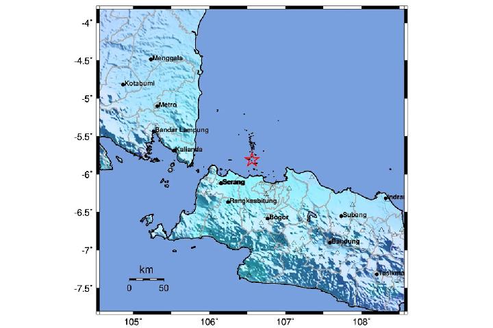
Kabarsaji.com – A powerful magnitude 6.5 earthquake struck the Java Sea early Saturday, September 12, 2026, sending shaking across a broad stretch of Indonesia despite occurring far beneath the seabed. The quake happened at 4:23 a.m. local time, with its epicenter about 69 kilometers northeast of the Thousand Islands off Jakarta.
The Meteorology, Climatology, and Geophysics Agency, or BMKG, said there was no tsunami potential from the event. Its depth was measured at 368 kilometers, placing it in the category of deep-focus earthquakes. Such earthquakes can be felt over exceptionally wide areas because seismic energy travels through deep layers of the Earth before reaching the surface.
“The earthquake’s epicenter was at a depth of 368 kilometers, classified as a deep-focus earthquake,” said Wijayanto, the Director of Earthquake and Tsunami at BMKG.
BMKG identified the source as intraslab activity involving an oblique-normal movement mechanism. Rather than being linked to movement on a shallow active fault, the rupture occurred within a section of the Australian Oceanic Plate that has descended beneath the Java Sea.
Strongest Shaking Reported in Southern Java Areas
The most intense shaking reached level IV on the Modified Mercalli Intensity scale in Pandeglang, Lebak, Serang, Sukabumi, Cianjur, and Tanggamus. At that level, many people can notice the motion whether inside or outside. Windows and doors may vibrate, walls can make creaking sounds, and fragile household items such as pottery may break.
This intensity scale describes what people experience at the surface, rather than the amount of energy released at the earthquake source. A single earthquake can therefore receive one magnitude measurement while producing different intensity levels from place to place. Distance, local ground conditions, building characteristics, and the path of seismic waves all influence how strongly residents feel an event.
Tangerang, North Jakarta, and Cilacap experienced level III MMI shaking. Indoor movement at that intensity can resemble the vibration created by a large truck passing nearby. It may be clearly noticeable to people at rest but is generally less disruptive than the stronger shaking reported in several locations farther south.
Lighter tremors extended over an even larger area, including Bandung, Yogyakarta, Pacitan, Ponorogo, Malang, Bengkulu, Padang, Mentawai, Pariaman, and Solok Selatan. The geographic reach, from parts of Sumatra across Java and toward Kalimantan, reflected the earthquake’s unusual depth and the way its energy weakened gradually over distance.
Why the Tremors Traveled So Far
Daryono of the Indonesian Disaster Experts Association explained that deep earthquakes can behave differently from more familiar shallow events. A hypocenter deeper than 300 kilometers is considered deep-focus, and the affected rock environment is relatively uniform compared with many shallower crustal zones.
“The earthquake occurred in the very homogeneous oceanic lithosphere at a depth of hundreds of kilometers; stress release tends to occur totally within a single main event,” he said.
That characteristic is significant for communities monitoring the possibility of follow-up shocks. BMKG monitoring through 5 a.m. recorded no subsequent earthquake activity. Daryono said earthquakes at this depth rarely generate aftershocks because much of the stress may be released in the main rupture.
The event was described as an intra-slab earthquake: rock inside the subducted Australian Oceanic Plate deformed and broke at great depth. Indonesia’s position near the meeting zones of major tectonic plates means earthquake activity is a continuing reality, but each event has its own mechanism, depth, and pattern of shaking.
Residents may find it surprising that the epicenter lay north of Jakarta while some of the strongest and earliest tremors were felt in southern Java, including Sukabumi. Daryono said seismic waves moved efficiently southward through the dense, uniform plate slab before spreading upward toward the surface.
“This happened because seismic waves propagate most efficiently through the dense and homogeneous plate slab medium towards the south before spreading to the surface,” said Daryono.
No Tsunami Warning Issued
Although the quake was strong, its great depth was a key reason BMKG did not identify a tsunami threat. Tsunamis are usually associated with substantial vertical displacement of the seafloor, particularly during shallower undersea earthquakes. A deep rupture can generate widespread ground motion without producing the seabed movement needed to displace a large volume of water.
The absence of a tsunami risk does not mean that broad regional shaking should be ignored. People who experience an earthquake should remain alert for official updates, assess their immediate surroundings, and avoid damaged structures until they can be checked safely. In areas where shaking is felt indoors, moving away from glass, unstable shelves, and heavy hanging objects can reduce injury risk during the motion.
For this event, authorities had not recorded aftershocks by the end of the initial monitoring period. The early-morning earthquake nevertheless served as a reminder of how a rupture deep below the Java Sea can be noticed across hundreds of kilometers, reaching communities well beyond the location of its epicenter.
Related Reading
Frequently Asked Questions
What is M6 5 Earthquake Rocks Java Sea North?
M6 5 Earthquake Rocks Java Sea North is the main topic of this guide. The article explains the context, practical details, and next steps readers should understand.
Why does M6 5 Earthquake Rocks Java Sea North matter?
M6 5 Earthquake Rocks Java Sea North matters because readers are looking for a useful answer, not just a short summary. Good content should match search intent and help them decide what to do next.