
Mount Semeru Eruption Triggers Ash Rain in Lumajang
Mount Semeru Eruption Triggers Ash Rain in Lumajang Mount Semeru Eruption Triggers Ash Rain - The eruption of Mount Semeru, Indonesia’s highest active
Mount Semeru Eruption Triggers Ash Rain in Lumajang
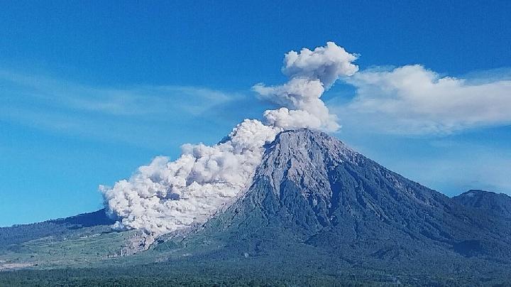
Mount Semeru Eruption Triggers Ash Rain – The eruption of Mount Semeru, Indonesia’s highest active volcano, has led to widespread ashfall in Lumajang Regency, prompting heightened vigilance among local residents. On July 15, 2026, the explosive activity from the mountain resulted in light ash rain that affected multiple regions, marking the latest in a sequence of volcanic disturbances that have been closely monitored by authorities. The event occurred at approximately 04:19 AM local time, with ash particles reaching an altitude of 1 kilometer above the summit. This incident underscores the ongoing volatility of the Semeru Eruption Triggers Ash Rain phenomenon, which has become a recurring concern for the area’s communities.
Seismic Activity and Eruption Dynamics
The Semeru Volcano Observatory (PGA), based in Mount Sawur, Sumber Wuluh Village, Candipuro District, reported that the ash plume was visible and dense, extending northeastward with a white to gray hue. According to PGA Semeru officer Sigit Rian Alfian, the eruption was recorded on seismographs with a maximum amplitude of 22 mm and a duration of 204 seconds. This data aligns with the pattern of seismic activity that has been observed in the region, offering critical insights into the volcano’s behavior.
“The eruption was recorded on seismographs with a maximum amplitude of 22 mm and a duration of 204 seconds,” said Sigit Rian Alfian.
Over the preceding six hours, seismic monitoring detected 12 tremors linked to the eruption, varying in amplitude from 10 to 22 mm and duration between 73 and 204 seconds. In addition, seven rockfall tremors were noted, characterized by smaller amplitudes (1–5 mm) and durations of 54–91 seconds. The PGA also recorded four blast tremors (2–7 mm amplitude, 51–64 seconds) and six harmonic tremors (1–15 mm amplitude, 97–539 seconds). A single distant tectonic tremor, measuring 12 mm in amplitude and lasting 64 seconds, was observed with an S-P interval of 19 seconds. These findings indicate a complex interplay of volcanic forces, including potential gas emissions and magma movement beneath the surface.
Risk Assessment and Evacuation Warnings
The Acting Head of the Regional Disaster Management Agency (BPBD) in Lumajang Regency, Isnugroho, confirmed that the alert level for Mount Semeru remains at III, emphasizing the continued risk of eruptive events. He noted that seismic data suggests the possibility of pyroclastic flows and lava activity, which have been a concern since July 11, 2026. During this period, volcanic dust has drifted toward Lumajang City, leading to sporadic ashfall and prompting safety advisories for the local population.
“We advise users of two-wheeled vehicles to wear masks,” Isnugroho stated on Wednesday.
Residents are recommended to avoid the southeast sector near Besuk Kobokan, up to 13 kilometers from the summit, due to the threat of pyroclastic flows and lava. Beyond this distance, individuals should maintain a safe distance from the riverbanks along Besuk Kobokan, within 500 meters of the edge, as ash and molten rock could extend up to 17 kilometers. A 5-kilometer radius around the crater or peak is designated as high-risk for flying debris, requiring people to take precautions against potential hazards in river valleys and smaller tributaries connected to the Besuk Kobokan river.
Community Response and Environmental Impact
As the eruption of Mount Semeru continued to unfold, local communities in Lumajang Regency swiftly adapted to the situation. Authorities issued evacuation guidelines, urging residents to stay informed and follow safety protocols. Schools and public facilities were temporarily closed, and transportation routes were reviewed to minimize exposure to ashfall. The ash rain caused by the eruption of Mount Semeru has impacted daily life, with visibility reduced in certain areas and respiratory issues reported among individuals exposed to the fine particles.
Environmental experts are monitoring the long-term effects of the ash rain on agriculture, water sources, and air quality. The fine ash particles from the eruption of Mount Semeru can settle on crops, potentially affecting yields, while also contaminating nearby water bodies. Air quality assessments have been conducted to ensure that the ashfall does not lead to prolonged health risks. These measures highlight the need for sustained preparedness in the face of volcanic activity.
Read: Mount Semeru Hit by 583 Eruptive Earthquake in Late May Click here to get the latest news updates from Tempo on Google News.
Mount Semeru Eruption Triggers Ash Rain in Lumajang has also drawn attention to the volcano’s historical activity. Known for its frequent eruptions, Semeru has been a focal point for geologists and disaster management teams. The recent event is part of a broader pattern of seismic and eruptive activity that has shaped the region’s response strategies. With the continued threat of ash rain, the local population remains on high alert, awaiting further developments from the PGA and BPBD.